[vc_row][vc_column][vc_video link=”https://youtu.be/feHYw7h3zQM” align=”center” title=”2017 Agriculture Promo – Great Lakes Drone Company”][/vc_column][/vc_row][vc_row][vc_column][vc_column_text]Rapid advancements in computer processing speeds, chips, and sensors have made UAVs less of a military gadget, and more of a tool for the general public to use. As such, the UAV ecosystem can spur massive transformations in industries like precision agriculture, which is ripe for disruption as water shortages, finite land resources and climate change are squeezing farmers around the world. The ability to capture and analyze crop data can arm farmers with unique insights and actionable data to cut costs as well as produce more crops with fewer resources.
The use of drones in agriculture is revolutionizing the agriculture industry by lowering growers’ costs while increasing harvest yields.
Multispectral imaging looks at visible light as well as near infrared (NIR) light reflected by plants as an early indication of health and vigor. Using drones to fly autonomous “mow the lawn” patterns, hundreds of multispectral images are collected and stitched together to form a single high-resolution image of grower’s field crops, vineyards or orchards. Multispectral images are converted into a normalized differential vegetative index (NDVI) map giving early indications of crop health and plant vigor.
Satellite images have provided NDVI images for decades, but are low resolution, have high latency on the order of three weeks, and are obstructed by cloud cover. With the advent of drones, lower cost multispectral cameras and powerful processing software, precision agriculture is revolutionizing the agriculture industry. Download Case Study Information
Check the ROI Calculator
(Our rates are not expressed in this calculation, this is based on max estimated costs versus ROI)
NDVI images show plant stress caused by:
- Nutrients
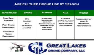
- Water stress
- Disease/molds
- Insect infestation
- Overall health status
- Crop damage and insurance claim
- Weed infestation
[/vc_column_text][/vc_column][/vc_row][vc_row][vc_column][vc_gallery interval=”5″ images=”1011,1073,55,1071,56,1072″ img_size=”large” title=”NDVI Field Drone Imagery Samples – What can your ROI become? “][/vc_column][/vc_row]
[vc_row][vc_column css=”.vc_custom_1536950562290{background-color: #f9f9f9 !important;}”][title align=”center”]Our Clients[/title][vc_tta_pageable no_fill_content_area=”1″ active_section=”1″ css=”.vc_custom_1536950471264{background-color: #f9f9f9 !important;}”][vc_tta_section title=”Section 1″ tab_id=”1536601420781-7546e101-82f2″][vc_row_inner][vc_column_inner width=”1/4″][vc_single_image image=”1538″ img_size=”full” alignment=”center”][/vc_column_inner][vc_column_inner width=”1/4″][vc_single_image image=”1539″ img_size=”full” alignment=”center”][/vc_column_inner][vc_column_inner width=”1/4″][vc_single_image image=”1540″ img_size=”full” alignment=”center”][/vc_column_inner][vc_column_inner width=”1/4″][vc_single_image image=”1541″ img_size=”full” alignment=”center”][/vc_column_inner][/vc_row_inner][/vc_tta_section][vc_tta_section title=”Section 2″ tab_id=”1536601420817-3abd0b09-2f30″][vc_row_inner][vc_column_inner width=”1/4″][vc_single_image image=”1542″ img_size=”full” alignment=”center”][/vc_column_inner][vc_column_inner width=”1/4″][vc_single_image image=”1543″ img_size=”full” alignment=”center”][/vc_column_inner][vc_column_inner width=”1/4″][vc_single_image image=”1544″ img_size=”full” alignment=”center”][/vc_column_inner][vc_column_inner width=”1/4″][vc_single_image image=”1545″ img_size=”full” alignment=”center”][/vc_column_inner][/vc_row_inner][/vc_tta_section][vc_tta_section title=”Section” tab_id=”1536601438187-fca2c651-cf98″][vc_row_inner][vc_column_inner width=”1/4″][vc_single_image image=”1546″ img_size=”full” alignment=”center”][/vc_column_inner][vc_column_inner width=”1/4″][vc_single_image image=”1548″ img_size=”full” alignment=”center”][/vc_column_inner][vc_column_inner width=”1/4″][vc_single_image image=”1547″ img_size=”full” alignment=”center”][/vc_column_inner][vc_column_inner width=”1/4″][vc_single_image image=”1553″ img_size=”full” alignment=”center”][/vc_column_inner][/vc_row_inner][/vc_tta_section][vc_tta_section title=”Section” tab_id=”1537192690367-d9e3dbbf-e9ef”][vc_row_inner][vc_column_inner width=”1/4″][vc_single_image image=”1555″ img_size=”full” alignment=”center”][/vc_column_inner][vc_column_inner width=”1/4″][vc_single_image image=”1556″ img_size=”full” alignment=”center”][/vc_column_inner][vc_column_inner width=”1/4″][vc_single_image image=”1557″ img_size=”full” alignment=”center”][/vc_column_inner][vc_column_inner width=”1/4″][vc_single_image image=”1558″ img_size=”full” alignment=”center”][/vc_column_inner][/vc_row_inner][/vc_tta_section][vc_tta_section title=”Section” tab_id=”1537192897780-ec5d290f-9e05″][vc_row_inner][vc_column_inner width=”1/4″][vc_single_image image=”1559″ img_size=”full” alignment=”center”][/vc_column_inner][vc_column_inner width=”1/4″][vc_single_image image=”1560″ img_size=”full” alignment=”center”][/vc_column_inner][vc_column_inner width=”1/4″][vc_single_image image=”1561″ img_size=”full” alignment=”center”][/vc_column_inner][vc_column_inner width=”1/4″][vc_single_image image=”1562″ img_size=”full” alignment=”center”][/vc_column_inner][/vc_row_inner][/vc_tta_section][vc_tta_section title=”Section” tab_id=”1537193076191-e1c5b0ab-a71f”][vc_row_inner][vc_column_inner][vc_single_image image=”1563″ img_size=”full” alignment=”center”][/vc_column_inner][/vc_row_inner][/vc_tta_section][/vc_tta_pageable][/vc_column][/vc_row]